Spiders by Latitude .. ?
-
 by
Kitharode
moderator
by
Kitharode
moderator
In winter the permanant ice cap of the south pole is covered by an icelayer up to 2-meters thick. The icelayer eventually extends to about 55 deg latitude. I'm assuming that at the limit of the icelayer we do not get a 2-meter wall of ice, but instead we would see the 'thin end of the wedge' as the temperature rises to the 'permanently warm' latitudes.
At the start of spring, as solar radiation begins to return to southern latitudes, the icelayer begins to retreat. The 'thin end of the wedge', being the last to be formed, will be the first to sublime. We are told that springtime is the time when venting will begin and the spider forming process gets underway.
This suggests to me that spider venting would occur first in the higher latitudes (say 60 - 70 deg) followed later in spring/summer by venting in lower latitudes (say 70 - 80 deg). Does anyone know if this is what actually happens?
Posted
-
 by
Portyankina
scientist
by
Portyankina
scientist
Hi!
I am sorry I missed this somehow, thanks for the reminder.
Yeh, we also thought this what will happen and activity will correlate with latitude. But no, no proof for it yet. Maybe all the data from planet4 will show some correlations. But there might be an explanation to not seeing the trend (we call it observational bias): to start from, spiders do not have a good coverage in latitude, they are mainly between 75S and 84S. 9 degrees might be just not enough to resolve the correlation. And even less of spider locations have a good temporal coverage by HiRISE to pin down rate of some kind of activity measure... But we'll keep trying.
Anya
Posted
-
by
Kitharode
moderator
Many thanks, Anya. That's a very surprising, but very interesting answer. Two more answers please;
Could you confirm (or deny) that my view of the edge of the icesheet, at about 55deg latitude, is a 'thin end of the wedge' and not a wall/cliff of ice.
If it is the 'end of a wedge', do we know how many degrees of latitude it takes to get from the 'thin end' to the 'full' thickness of the icelayer.
Posted
-
by
Portyankina
scientist
-
Yes, you are right on average. But it is also not continuous thin edge, it's more like patchy coverage: more ice in shadows and less on inclined surfaces exposed to sunlight.
-
It is a relatively smooth curve, if one thinks about average seasonal ice thickness vs latitude. I am trying to find the figure illustrating that curve by laser altimeter data, will post if I dig it out.
Anya
Posted
-
-
by
Kitharode
moderator
Thanks again Anya. Fingers crossed you find that figure of data. Would be useful for trying out some calculations.
Posted
-
by
Portyankina
scientist
Here you go
and more scientific plot with better annotations
Posted
-
 by
wassock
moderator
by
wassock
moderator
So between75 and 84 degrees,where the spiders form, we're looking at 50 cm plus or minus 10 of forming and subliming ice?
Posted
-
by
Kitharode
moderator
Yes I think so. And this 50cm layer is formed above the 0.4 meters of icelayer already formed. This is useful stuff, methinks, for getting a few parameters in place concerning spider formation. Hmmm....
Posted
-
by
wassock
moderator
Where does the .4 come into it?
Posted
-
by
Kitharode
moderator
Ermm...Good question. Don't know what I was thinking. Please ignore and I'll come back with something 'sensible' later on. 😉
Posted
-
by
Portyankina
scientist
in response to wassock's comment.
That's right.
BTW I only now realized that north is actually same till lat = 80! I need to check if there is more similarity between our southern targets and northern equator-wise 80 deg. Those northern targets at higher lats must behave differently, maybe slower/later start. Would be nice detail! Thanks!
Anya
Posted
-
by
wassock
moderator
OK so now it appears that fans only form from ice between 40 and 60cm thick? But the process would not appear to follow the ice thickness south as it melts?
Is ice thicker than 60cm too thick for enough sunlight to penetrate? Or too thick for holes to form?
Is ice thinner than 40 too weak to permit enough pressure to build for vented gas speeds to pick up dust?
Is the suns angle important wrt the amount of energy that gets through the ice, and thus the reason that as the sun gets higher the fans dont follow the melting ice? Not sure how that one works as the sun gets higher more energy out to get through.
Posted
-
by
Kitharode
moderator
in response to Portyankina's comment.
The jump in the northern line on the graph is something I'd noticed, but I'd put it down to the different 'heights' of the two poles. But slower/later hadn't entered my head. My immediate reaction to that idea is the 'highly' elliptical orbit of Mars and the resulting short northern winter / long southern winter situation.
Speaking of which, the icelayer forms from (roughly) the autumn equinox into winter as Mars is slowing down on its way to aphelion. The icelayer retreat begins (again roughly) in spring as Mars speeds up on its way to perihelion. Does it follow then that the icelayer retreats more quickly than it forms? Seems like it to me, but perhaps the ellipticity is not enough to be significant.
But if the idea is true, it might tell us something - even if I've no idea what!!
Posted
-
by
Kitharode
moderator
in response to Portyankina's comment.
Wassock. Exactly. We're into parameters here, as well as some great questioning.
Posted
-
by
Kitharode
moderator
As springtime sets in, at the outer fringe of the icelayer, the frosty bits sublime directly into the atmosphere. The thinnest parts of the ice layer do the same, subliming from the surface directly, getting thinner and disappearing. But when the ice is thick enough (and that’s what I want to find out) then sublimation occurs on the underside of the ice. This suggests to me that there must always be an ‘ice barrier’ between the two processes. If that is true, it also suggests that the underside sublimation process is always taking place at lower latitudes than direct sublimation. If this ‘ice barrier’ exists it will migrate southwards from its origin at latitude x.
So my question is; What thickness of ice is required for the solid-state greenhouse effect to come into effect and how does that thickness compare to the thickness of the icelayer at latitude 75deg at the right time of year?
Posted
-
by
wassock
moderator
Not sure that the green house, or not, matters too much. To my mind when it warms up the ice will sublime wherever theres space for it to do so. In terms of fans the gas has to move fast enough to create some sort of turbulent flow and pick up bits of dust. So either lots gas needs to br form quickly or pressure has to build and then vent. You can imagine that thin ice will have lots of holes and cracks so the underside is effectively open to atmosphere. And maybe thick ice just doesnt rupture.
Anya, anything to suggest a variation in opacity of the ice according to latitude? As I'm reading things the winter freeze depletes the atmospheric CO2 significantly. The ice will form and spread from the pole 8utwards thus the initial ice at higher latitude is formed from a higher atmospheric concentration than the ice a lower latitude which forms later. Could this affect the properties of the ice?
Posted
-
by
Kitharode
moderator
Now, I thought that the greenhouse was one of the main driving forces of fan formation. My understanding was that without the solid-state greenhouse we wouldn't get the 'underside' heating, so no trapped gas, so no vent. Am I missing a point somewhere?
In your second paragraph I'm thinking you may have mixed up your 'higher' and 'lower' latitudes. The lower latitudes (high numbers) forms ice first. The higher latitudes (low numbers) forms later. You were probably thinking about your higher/lower concentrations of atmosphere while you were typing. I've read 25-30% depletion of atmosphere in winter.
Posted
-
by
wassock
moderator
No simpler than that i was thinking 90 is higher than 10. Your probly right about green houses, something has to push the sub ice sumblimation
Posted
-
by
Kitharode
moderator
This is going to be useful to me and may be of interest to you. From a HiRISE research page:
"The measured temperature (148 K) leads to a deposition rate of 45 µg/m2/s which, assuming a frost bulk density of around 1 g/cm3, leads to a build-up of a CO2 frost layer at a rate of around 4 mm per day or approximately a 1.3 m layer over the entire Martian winter season."
Lots more useful info and some great 'side by side' comparison photos on the page. Anya gets a mention too! http://space.unibe.ch/staff/thomas/hirise_research.htm
Posted
-
 by
AUricle
by
AUricle
Interesting that scientists are opposed to a term like "spiders" while they have no problem with "Inca City".
Can anyone explain the obvious duplicity?Posted
-
 by
mschwamb
scientist, translator
in response to AUricle's comment.
by
mschwamb
scientist, translator
in response to AUricle's comment.
sometimes when you submit a paper to a scientific journal the referee (another scientist in the field who reads the paper and recommends to the editor whether the paper is of scientific merit and raises concerns and criticisms that need to be addressed before acceptance) doesn't like your name for a feature and makes you change it. In this case I believe it was the referee didn't like spider because of confusion with the insect on Earth but was fine with araneiform.
Cheers,
~Meg
Posted
-
by
Kitharode
moderator
Made a huge blunder in one of my earlier posts (yes, I know it's not the first time) so here's the correction. I was describing the orbit of Mars and the advance/retreat of the icelayer. I said that from the autumn equinox the icelayer begins to form and it extends throughout winter, reaching latitude ~60deg S by aphelion. That bits OK.
But then I said that from early spring the icelayer begins to retreat throughout spring into summer. This is WRONG. It's much nearer the truth to say that on the day of arrival at aphelion solar radiation has retreated to 60degS and the icelayer has extended in line with this. On the day of departure from aphelion, however, the Sun has already begun to return to more southerly latitudes and the icelayer will begin to retreat straight away. By the time of early spring, a significant retreat of the icelayer has already occured.
My 'huge blunder' was visualising the fully formed icelayer being carried through a 'quarter' of Mars' orbit and needing to reach the spring equinox to begin its sublimation. In fact, the icelayer has all but disappeared by the spring equinox. Hope that's clear (and correct) 😉
Haven't done the calculations yet, but I'm going to hazard a guess that the 'significant retreat' of the icelayer by the time of early spring gets to about latitude 75 S, on the border of the spider forming region (75 - 84 degS).
AUricle: Welcome to Manhatten !!
Posted
-
by
Portyankina
scientist
Regarding the minimum/max ice depth necessary for forming spiders:
Minimum thickness is restricted by the ability of the layer to withhold the pressure long enough to make any surface erosion underneath possible. Very thin brittle layer or very thick but fluffy layer with lots of pathways for gas to escape - both will fail to create spiders.
In addition, if the layer is too thick and dirty - not enough light will get down to substrate to start the sublimation. But this is proven not to matter for whole southern polar cap, enough sun in spring mostly everywhere (apart from shadowed places). Also, if there is water ice below the seasonal CO2 layer, it reflects back too much light and something else but not spiders will form.
Anya
Posted
-
by
Kitharode
moderator
Many thanks Anya. (I've been composing this post whilst you were posting here, so slight crossover at the end).
Using my imagination I can easily see how, on the broadest scale, we might consider the situation at the 'edge' of the icelayer to be - ‘there’s ice, or there isn’t any ice’. That is, I'm ignoring the frosty patches and giving the icelayer a hard edge round its 'circumference'.
To improve my view I was prompted to do some number crunching. In round numbers…
(Mars circumference) 360deg = 21,337km. Therefore, 1deg = 60km.
Extent of winter icelayer from pole to latitude 60S = 30deg = 1,800km.
Main spider venting occurs between latitudes 75 to 85 = 10deg = 600km.
Messing about with some sketches and graphs suggests to me that by early spring the ‘edge’ of the icelayer will have retreated to around latitude 75, and the thickness of the 600km venting zone ice will be in the region of 0cm – 28cm. (Please think 'back of the envelope' with that bit).
All this paints a very different picture to the one I’ve been carrying around and it radically changes any parameters that were in that picture. I’m still hoping someone can provide a min/max thickness of ice for solid-state greenhouse to kick in. Hopefully it’ll be about 2cm/20cm – Fingers crossed.
Posted
-
by
Portyankina
scientist
in response to Kitharode's comment.
Hi!
I am not sure I understood everything right. But I just wanted to show you these plots too, they show how elevation, i.e. ice layer thickness changes with season (Ls - is seasonal measure on Mars, you can see the explanation of it here) at different latitudes:
These plots, as well as those I posted before, are not mine! They are from Science paper "Seasonal Variations of Snow Depth on Mars" by Dave Smith and co.
Posted
-
by
Kitharode
moderator
Wonderful stuff. Thanks Anya. I'll enjoy getting to grips with them. There's nothing yet for you to understand, so don't worry, I'm just trying to get 'the big picture'. Thanks also for reference to the science paper.
Posted
-
by
Kitharode
moderator
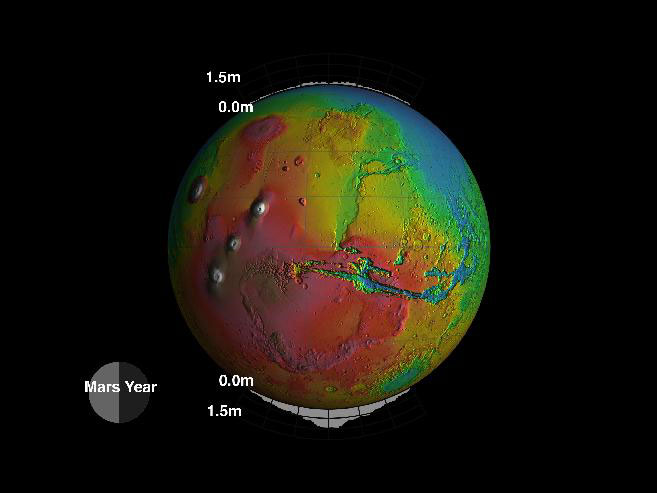
Here is most of the Abstract from the aforementioned science paper. Very informative.
"Using topography collected over one martian year ... we have measured temporal changes in the elevation of the martian surface that correlate with the seasonal cycle of carbon dioxide exchange between the surface and atmosphere.
The greatest elevation change (1.5 to 2 meters) occurs at high latitudes (above 80°), whereas the bulk of the mass exchange occurs at lower latitudes (below 75° N and below 73° S).
An unexpected period of sublimation was observed during northern hemisphere autumn, coincident with dust storms in the southern hemisphere. Analysis of MGS Doppler tracking residuals revealed temporal variations in the flattening of Mars that correlate with elevation changes. The combined changes in gravity and elevation constrain the average density of seasonally deposited carbon dioxide to be 910 ± 230 kilograms per cubic meter, which is considerably denser than terrestrial snow".
Q1. The bulk of the mass at lower latitudes - Because of increasing surface area? (need a calculator)
Q2. How does solar longitude (on plots above) get to 540deg? (need a scientist)
Posted
-
by
wassock
moderator
in response to Portyankina's comment.
Anya, whats going on in the summer? The plots make it look like theres an increase in elevation after a late spring minima which continues through the summer. Is this due to something happening at the latitudes plotted or at the 60 degree datum point?
Posted
-
by
Portyankina
scientist
in response to Kitharode's comment.
Q1: Yes, simple integration.
Q2: They just did not bother to go to 0 after 360 of Ls.Posted
-
by
Portyankina
scientist
in response to wassock's comment.
Truly saying, I don't know. Let's first pin that we are talking about the same thing: do you mean north or south? and which 60 deg datum?
For me the weird behavior is in southern hemisphere from Ls=240 - the increase from here and to 290 I do not understand. It might be because of 2 reasons: either 1) the same off-season sublimation mentioned for North because of the dust storm also worked in the South. SO sublimation should have been slower and longer but because atmosphere was too warm for the season it first sublimed a lot and then condensed some ice back. Or 2) it has smth to do with there normalization towards latitude 60S.
Posted
-
by
wassock
moderator
in response to Portyankina's comment.
I'm loking at the south too.
As i read the graph it's showing the change in height a various latitudes relative to the height at latitude of 60 degrees. So measure the height when theres no ice at 60 and (say) 80 and call the difference in height delta h= zero. Re measure when theres 50 cm of ice at 80 and none at 60 and we get delta h = 0.5M.
If this how the graph works then the summer increase at 80 could be explained by a reduction in height at 60 giving a bigger difference between the 2 points.Having Written that down it all looks rather shaky, is there a description of what the measurements mean?
Posted
-
by
Kitharode
moderator
in response to wassock's comment.
I think you've just described what's going on. I was trying to clear it up in my head so I've reread the plot text, and your post, and I'm sure what you say is correct. (Second opinion always useful of course)!
In the south the icelayer extends to lat 60 ish, must be similar in north, so maybe that's it? I think you have it.
Posted
-
by
Kitharode
moderator
in response to wassock's comment.
Ah yes. I see it now. We need to know if 60 is always seen as zero. That right?
Posted
-
by
wassock
moderator
Think so, thats how I make sense of the units they are using least wise. More that 60 is invariate so that any change in the difference inheight between 60 and where we're measuring "must" be due to ice at the measure point
Posted
-
by
Kitharode
moderator
That works for me. Have you tried putting the 'plots' diagram together with the delta-h charts? I haven't yet, but I'm guessing that there's got to be yet another view to be had of this icelayer. Gonna play around with pen and paper when I get time.
If we did any work with 60=zero as datum point and it turned out different, do you think we'd be able to take our results and, for example, multiple everything by 0.26 to make it right (if you get my drift)?
Posted
-
by
Kitharode
moderator
Until I'm told otherwise, I'm gonna use your Latitude 60 = zero 'datum point' if I do any calculating/measuring. I've nothing yet, but if any numbers come up that's what I'll be working with.
If the delta-h anomaly is due to the dust storm indicated in the diagram (and its got to be a strong contender) then dust storms are more capable of affecting major change on Mars than I ever imagined and/or the martian system is more fragile, or finely balanced, than I'd expected.
Are you doing any work on dust storms and their impact? Having built up a decent overall view of the southern hemisphere, maybe this would be a place to put forward any ideas on that? Perhaps somebody's got some general facts, figures, abstracts, links, to go with the plots we have. Hope so.
Posted
-
by
Kitharode
moderator
Heavy science, lots of maths and physics, but a stack of useful information also. Lots of icelayer stats:
http://epubl.ltu.se/1402-1617/2010/057/LTU-EX-10057-SE.pdf
Posted
-
by
Kitharode
moderator
Subsurface CO2 gas flow in Mars' polar regions:
Gas transport under constant production rate conditions.N. Thomas, G. Portyankina, C. J. Hansen, A. Pommerol.
Sublimation at the ice-substrate interface with pressure build-up is an accepted mechanism for the production of fan deposits on the southern polar CO2 ice cap on Mars. Fluid dynamics modeling has been used to investigate gas outflow through vents in a CO2 slab ice.
Small (5–25 m in length) fan deposits seen on the annual southern CO2 ice cap can be produced by a steady-state in which open vents continuously outgas in response to sub-surface sublimation generated by diurnal energy input through translucent impermeable (to gas) ice slabs. This would produce diurnally-controlled deposits which would change orientation with time in response to winds thereby explaining observations made by HiRISE on MRO.
Gas flow below the ice can reach up to 25 m/s close to the vent. Dust flow in the sub-ice cavity has also been computed but velocities are much lower with the main acceleration occurring <0.5 m from the vent. This indicates that erosion is likely to be restricted to the immediate vicinity of the vent unless channels form in the cavity between the ice and the surface.
Journal: Geophysical Research Letters - GEOPHYS RES LETT , vol. 38, no. 8, 2011
Posted