Look at the spiders on that! (As they say)
-
 by
wassock
moderator
by
wassock
moderator
Look at these:
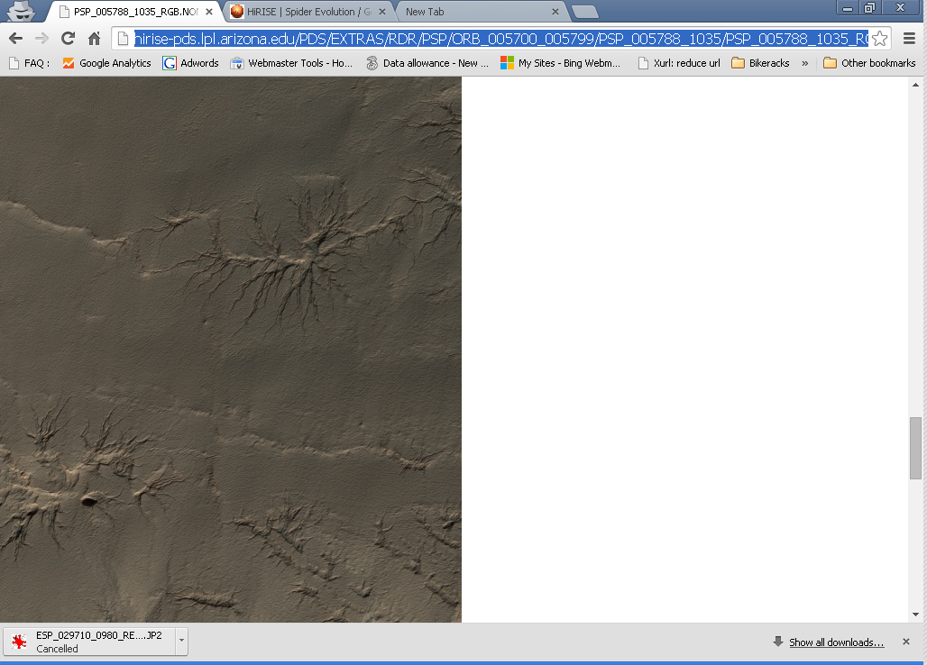
Now be prepared for the full image of the area
HiRise page for these here:
http://www.uahirise.org/PSP_005788_1035
Posted
-
by
wassock
moderator
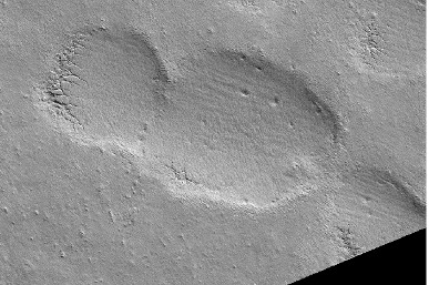
Now to this image, are these holes or lumps? The image is from 2007 Southern Sumer (SL334.4) and taken at 3:24PM so the sun ought to be out to the left somewhere?
There's a second image of the same area from 2013 3:04 PM and SL340 and the shadow on the larger object is 'exactly' the same shape (http://www.uahirise.org/ESP_032384_1035).I am assuming that Mars goes round the same way wrt the poles? - sun rises in the east and sets in the West?
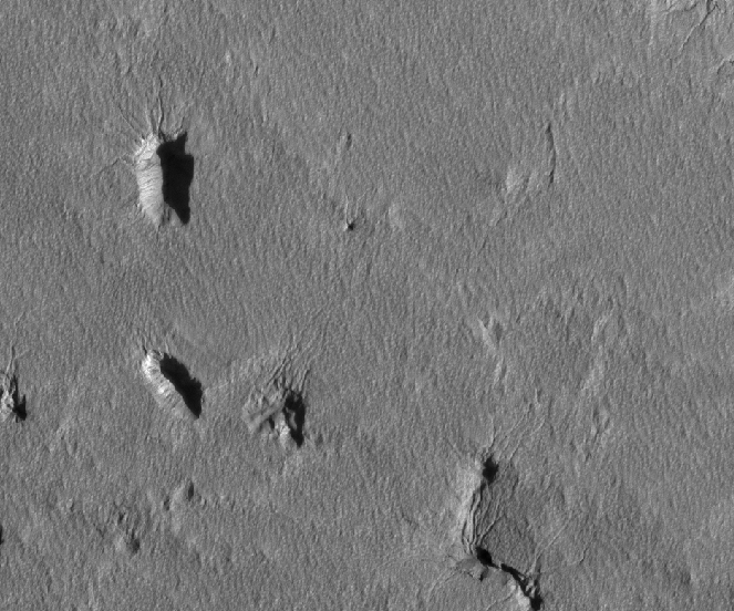
The context map on HiRise shows this image as aligned 11 to 5 o'clock whereas the actual map aligned image is presented more nine thirty to half 4 which doesn't make things any clearer.
Posted
-
 by
mschwamb
scientist, translator
in response to wassock's comment.
by
mschwamb
scientist, translator
in response to wassock's comment.
I am assuming that Mars goes round the same way wrt the poles? - sun rises in the east and sets in the West?
Yes, Mars and Earth rotate in the same direction. Only planet's that don't are Venus and Uranus. Venus rotates retrograde compared to the rest of the planets, and Uranus got tiled onto it's axis (I think likely due to impacts).
Cheers,
~Meg
Posted
-
by
mschwamb
scientist, translator
in response to wassock's comment.
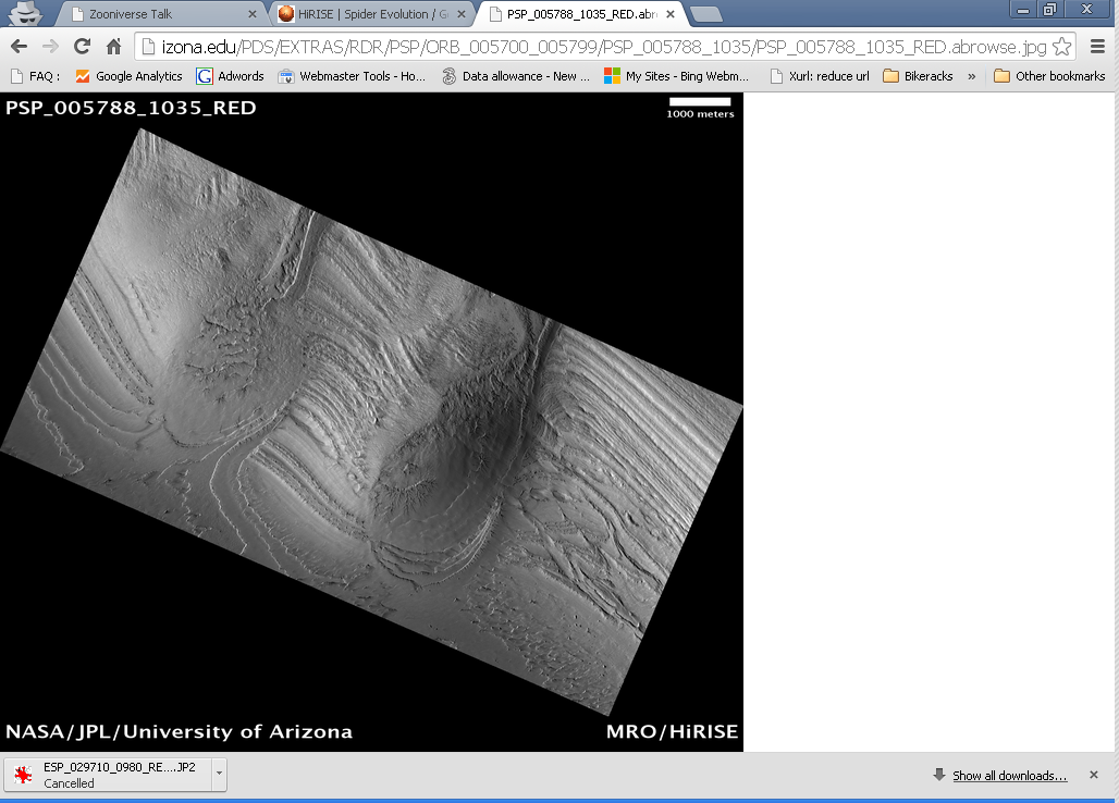
That's a stunning image of the Southern Polar Layered Deposits. Thanks for posting.
Cheers,
~Meg
Posted
-
by
wassock
moderator
in response to mschwamb's comment.
So where do you place the sun for the images? The large spiders seem to me to put it to the right which is the wrong place if this is map aligned and mid afternoon
Posted
-
 by
Kitharode
moderator
by
Kitharode
moderator
I love those images. Fabulous. Can't help with map orientation and such, I've not got into that yet.
I agree with Meg that planet Uranus is tilted (90+deg) probably due to collision. With Venus there are two views to the situation: It has a retrograde rotation, or it has a prograde rotation but is tilted by 180deg. Meg's choice of 'retrograde' is the one most widely used. 😃
Holes, not bumps, is what I see wassock. The lighting of the channels suggest this to me and also the shadow falling 'into the hole'. To me the outline of the shadow fits the right-hand contour of the hole, but would be a different shape if it were following a 'central ridge' of a bump.
Posted
-
 by
JellyMonster
by
JellyMonster
Yes, same here, holes and cracks.
Posted
-
by
wassock
moderator
in response to Kitharode's comment.
But that puts the sun in the East, if the image is map aligned, at 3 in the afternoon.............
Holes fits with what the channels look like so that means that the orientation information is Wrong?
Posted
-
by
mschwamb
scientist, translator
in response to wassock's comment.
This might help - from the HIRISE FAQ (any time I've dealt with Mars orbiter images I've never actually had to worry about Sun angle)
What is Phase Angle?
This is the angle between the sun, the surface, and the HiRISE camera
at the time the picture was obtained.What is Solar Incidence Angle?
Derived for the center of the image, this is the angle between the Sun and a "normal" drawn perpendicular
to the planet's surface at the time the image was acquired. A higher
incidence angle means that a person standing on the ground would see
the sun lower toward the horizon.So you should be able to use those values listed on the HiRISE public pages to figure the Sun angle.
Cheers,
~Meg
Posted
-
by
wassock
moderator
in response to mschwamb's comment.
Phase angle is 59.2 and solar incidence is 71 putting the sun 19 degrees above the horizon.
Which corner of the sun/surface/HiRise triangle is the phase angle representing? Either way neither value gives the direction of the sun.
Posted
-
by
JellyMonster
I rotated the image through 90° by accident and not the usual 180 (although in this case it doesn't really matter which). Obviously not conclusive proof but it is consistent with what we know already.
Posted
-
by
wassock
moderator
in response to JellyMonster's comment.
Jelly the image is supposed to be map oriented to start with an so ought not need turning round, but it's looking like thats not the case.
The image is supposed to be "polar stereographic" which supposedly distorts the image, in some way - but the image presented is the same shape as one taken at the equator. Does the map orientation related to the lat and longitude only or are the actual images being stretched and squashed? Far as I can see hirise doesnt care where it is, the images will cover the same area of the ball beneath it whereever it snaps. Its only when you try to put artificial lines drawn on the ball onto the images that it gets tricky.
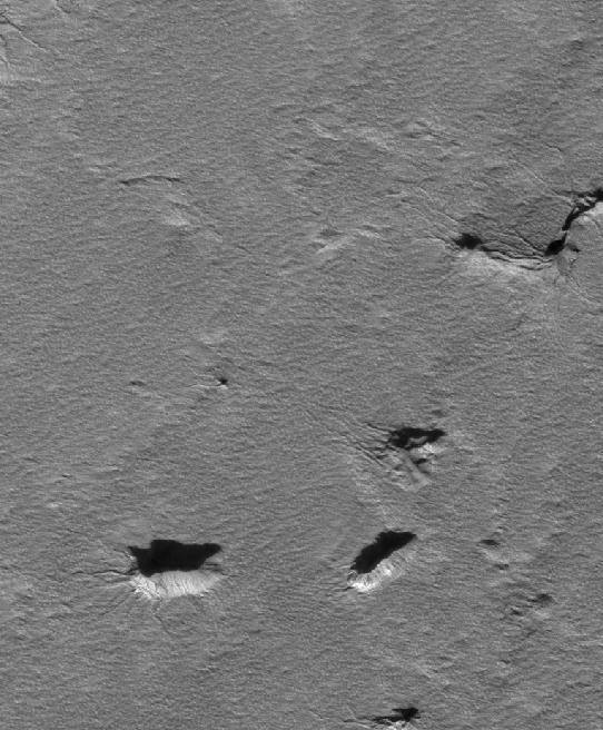
Any way lets get back to the point of posting the image in the first place. Consider the channels connecting to the large hole. They get wider as they approach the hole and, far as can be seen, stay wide as they decend into the hole. Erosion features getting wide as they go down I believe = liquid erosion? As a comparison take a look at the channels in the (alledged) fossil crater which get wider as they rise.
Posted
-
 by
michaelaye
scientist
by
michaelaye
scientist
Hey all,
so here's how you figure out the sun direction in general. On the HiRISE image webpages all important observational parameters are given in that Observation toolbox.Concerning the sun direction, we call that azimuth in astronomy (at least in some of the many coordinate systems possible), and the full name here is sub-solar azimuth, in other words, in what direction of the image is the point on the surface that lies directly under the sun, i.e. sub-solar.
Now, first one needs to take the right angle for the image product of interest: both solar azimuths for map-projected and non-map-projected images are provided.
Now, how to apply that angle: 0 is defined as a straight line to the right (= 3 o'clock), starting from the image center and increasing the angles clock-wise.
In this example, looking at a non-map-projected image, the solar azimuth is given as 53.7 degrees, so starting from '3 o'clock, an angle of approx 54 degrees is the well-known lower right that we have in most of our images in Planet4.
I have made a screenshot of a 100% zoom-in of one of the big holes taken from a non-map-projected image here, and one can see that the sun coming from the lower right makes perfectly sense: https://www.dropbox.com/s/gtb19a7pg6sdvv4/Screenshot 2014-04-17 17.54.09.pdfBy the way, if you want a powerful fast image viewer for the gigantic JP2 images, get a free copy here: http://pirlwww.lpl.arizona.edu/software/registration/registration.cgi?software=HiView
HTH,
MichaelPosted
-
by
michaelaye
scientist
By the way, these huge holes are quite interesting, thanks for the find, will keep these in mind.
Posted
-
by
wassock
moderator
in response to michaelaye's comment.
Thanks Michael. The problems is that the HiRise page says that this image (PSP_005788_1035_RED) IS map oriented with solar azimuth of 348.4 degrees which makes no sense. The greyscale JP2 image comes up with the same orientation as the .jpg greyscale.n The point of the exercise is to try and understand the HiRise images. "Map projected" appears not to mean that and the map projected images tend to come up in a different orientation the what is shown in the context map at the bottom. I have asked the question direct to HiRise but no reply.
Posted
-
by
michaelaye
scientist
Each HiRISE image either exists as map projected or not, and each of these in different resolutions. When recorded, it's not yet map projected, and all of Planet 4 data is NOT map projected. So, also for PSP_005788_1035_RED there is a non-map-projected and a map-projected (and a JP2 and a jpg) and which one it is is made clear in the filename of the download link.
If you still think something doesn't make sense, please provide a link to the exact product you are talking about, precise what detail does not make sense to you and then I can have a look. Just providing the image id as above is not helping because all kinds of products exist for all image ids.Posted
-
by
wassock
moderator
Michael, as stated in the first post in this thread all the images I'm using are the map projected ones. The greyscale.jpg map aligned image is shown in that post and it's full URL is http://hirise-pds.lpl.arizona.edu/PDS/EXTRAS/RDR/PSP/ORB_005700_005799/PSP_005788_1035/PSP_005788_1035_RED.abrowse.jpg
The map projected jp2 has the same alignment
The problem, is 2 fold:
The sun appears the be somewhere to the right but the time is mid afternoon
And the alignment of the image as presented (sort of sloping 10:30 to 4:30) is different to that on the context map from the bottom of the HiRise page where it is shown as more 11:00 to 5:00
Posted
-
by
michaelaye
scientist
- You are still not precise about your problem. I assume you expect the sun somewhere else for it being mid afternoon?
It fit's for me:
North is at approx 45 degrees for the map-projected images (see in table: "North azimuth", i.e. at 4:30 o'clock in 'watch coordinates'. The solar azimuth is at 348 degrees, that's 12 degrees less than 3 o'clock in watch coordinates. So definitely in the west, which I assume was your problem? If not, keep asking! 😉- Well observed! It is indeed different in the overview map. I don't know the precise reason (I have asked someone), but I bet it is this: I have confirmed that for equatorial images this differences does not exist (see here: http://www.uahirise.org/ESP_011292_1720), and whenever something behaves different at the equators compared to polar areas, in 90% of cases it has something to do with the chosen map projection (there exist literally hundreds).
For some reason the overview or context map has a different map projection than the one used for polar HiRISE images. I also would bet that this is because the chosen Google interface (as is obvious from the look of it) does not allow the same map projections then the team (and most of geographers) prefer for polar areas, which is the 'polar-stereographic' (http://hirise.lpl.arizona.edu/faq/#Stereographic)
Hope this helps?
Posted
-
by
michaelaye
scientist
In case you wonder why North is not somewhere more reasonable or standard, consider this:
The polar stereographic projection is designed to work for images containing the pole. Now imagine an image where you see the south pole. Which direction in the image is north?It is in every direction that points away from the south pole. This means that orientation wise there is no obvious simple choice. The choice that was eventually done relates to put the meridian at a defined place, often being the 'up' direction in a total map that would contain the overview with the pole in the view.
Now the last point to consider: Our images in Planet4 are still at quite a distance to the pole that's why they never contain the pole itself. The maths of map projection will rotate the image now in a way that, if placed into a larger map that 'would' contain the pole, the meridian is placed to go from center to bottom (see also the paragraph explaining the data flag "MAP_PROJECTION_ROTATION" in this document: http://hirise.lpl.arizona.edu/pdf/HiRISE_RDR_SIS.pdf ).
That oughta do it! 😉
Posted
-
by
michaelaye
scientist
Oh, and a shout-out to Meg who keeps redirecting me here as I still haven't put it into my regular schedule to come back here. Sorry for that.
Posted
-
by
wassock
moderator
Thanks for your patience Michael _seems my problem was in not asking WHICH map the images were projected onto? I was just assuming that map projected should put North at the top (as it appears to be in the context map) - dhooh!
Just so I have it straight - if we look at 'the map' of the south pole the pole will be at the centre with the 0/180 meridians running Right to Left and meeting at the pole. The position of North for any part of the bigger map then depends on where it is on the map. So a slice of this larger map which happens the be on the 0 meridian will have North at the Right, one on the 180 line will have North at the Left, on the 90 or 270 line at 45 to the vertical . Do I have that straight?
The context maps show the image as aligned north at the top, and the difference between the HiRise images and the context map varies, I assume, depending on where around the globe we are - on the 0 line it should be the same. This also would explain why some times there's a slight change and others the orientation is completely different.
Hopefully you'll be able to confirm that I now have some grasp of what's going on - I can then try to get my head round applying that to the actual images.
Posted
-
by
michaelaye
scientist
So, I just got confirmed what you already deduced for yourself: The context images always are north up. Then, images taken between, I think it was, 75 north and 75 south are in equatorial projection, with the chosen rotation of north up always. So the north azimuth in those images will always be 270 degrees (i.e. image up).
For the polar map you have complete rotational freedom, so it was defined as so: 0 deg is at top of the image for souhpole maps/images. I wrote center to bottom before for the zero meridian (i.e. bottom), but I confused that with the northpole, where 180 deg is at the top. So I think all your above interpretations are correct. Note also another helpful bit of knowledge: The spacecraft is in an almost perfect polar orbit, so the long image stripes, when map-projected, ALWAYS point between north and south, one just have to make the quick check with the north azimuth data value, which side is north.
Posted
-
by
michaelaye
scientist
To be more clear, Planet4 does not have equatorial images, I just brought this up for comparison, e.g. http://www.uahirise.org/ESP_011292_1720. All of the images in Planet4 are not map-projected, but the map-projected versions when looked up at the HiRISE images are ALWAYS polar stereographic projection that follow above described layout pattern.
Posted
-
by
wassock
moderator
OK think we got there in the end, thanks again and back to the pictures
Posted