Evolution or degradation?
-
 by
wassock
moderator
by
wassock
moderator
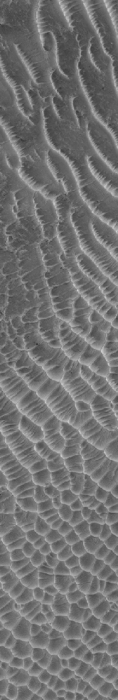
Take a look at the image below, which as an aside includes an object much featured here, and scroll down it observing how the terrain changes as you go. Ignoring the smooth stuff at the top and bottom is the landscape at the top evolving into what you get towards the bottom or is the bottom eroding to become the top? Or something else entirely?
The hirise page for this is herehttp://hirise.lpl.arizona.edu/ESP_011348_0950

Posted
-
 by
p.titchin
by
p.titchin
Amazing strip! Does the terrain have to evolve from one to the other. Could it just be like looking at the lake district,and scanning down to East Anglia. I like the variations in wind direction over the section with vents. Good game here for the 'met people' Any info on the distances covered?
Posted
-
by
JellyMonster
Paul Johnson's 'space chimney' anomaly is in there.
Posted
-
by
wassock
moderator
It's about 50 km top to bottom. It's the way at the top it's clearly one type of terrain and at the bottom a very different type but there's a smooth transition between the 2 which makes it look like one end is turning into the other end, maybe?
Posted
-
 by
Kitharode
moderator
by
Kitharode
moderator
Phew! I can see this discussion ending up as long as the image. Great stuff wassock. It tempts me to suggest a '2nd Rule of Mars' which states "The more you learn - The less you know".
The latitude is -85deg, so we're very near the south pole. In winter then, most icecover for longest time. If there's a permafrost shrinking, polygon shaping, ice-wedge thingy process going on (as I believe there is) then a lot of the spidery terrain makes sense, leading me to believe that there is an evolution going on but that the evolution is from the centre of the image. Roughly put, spiderland is evolving and it is also speading (up and down the image).
Very much 'off the top of my head' thinking, so could be wildly different of course. Here's the polygon wedgy thingy on Earth: http://www.arctic.uoguelph.ca/cpe/environments/land/features/freeze-thaw/icewedge_polygons.htm
Posted
-
by
wassock
moderator
What I'm seeing is individual pits at the top grading to pits in gullies grading to gullies grading to gullies with side arms grading to linear spiders grading to polygonal spiders then back to linear spiders then petering out to individual pits again.
I can see how that works as an evolution from the top down but don't see spiders turning into individual pits without some serious erosion mechanism going on.btw I was browsing the HiRes images and came across a description, somewhere, of a 'bulge' which has polygonal spiderlike/crack features on it - this is somewhere non polar and the suggestion was made that this indicates that the bulge is full of ice..
Posted
-
by
Kitharode
moderator
You're seeing pits at the top. So light coming in from bottom right of image hits the 'up side' of the pit making it bright, with the 'down side' of the pit being in shadow, therefore darker. That right? If it is, let's look at the bottom of the image where there are a fair number of pits, but do you see the small, fainter, elongated objects that appear to be lit up on the lower side, with 'shadow' above it. This suggests bumps. Round pits and long raised bumps in the same area is interesting - if that's what they are. Your eyes may be better than mine.
Thanks for the 'bulge' info. I'll look out for that.
Posted
-
by
wassock
moderator
I want to see boulders at the top, but I'm making myself think they're pits cos if they're not then all the spiders in the middle are ridges. See what you mean about the bits at the bottom. Remember the this is down side up so the South is UP (and at about 45 degrees orientation west to east, south to north)
Posted
-
by
Kitharode
moderator
Thanks for the reminder about south at the top. Easy to forget such things when they might be important.
Totally with you on the 'want to see boulders' thing, but as you explained they must be pits. Again at the bottom of the image, do you see the tight honey-comb effect just showing through the background of the image. Very suggestive of an extreme 'lace terrain' showing through thin ice. It might not be that, but that's the visual effect I'm getting.
Part of an evolution? Layering of spider terrain over x million year cycles? We've got images like this http://planetfour.org/subjects/standard/50e742b85e2ed211dc002aad.jpg but of course all this is guesswork
Loads going on....
Posted
-
 by
mschwamb
scientist, translator
by
mschwamb
scientist, translator
I wanted to post the response from Candy Hansen, Planet Four PI -
Just a quick response to Wassock's questions - fans are definitely
influenced by both wind and slopes. This is really evident in
seasonal images in the north on the sand dunes there. On the very
long image the erosion is greater at the top than at the bottom. It's
a beautiful interplay of the polygonal structures caused by ground ice
below the surface that has weak interfaces at the surface that the
seasonal CO2 gas erodes. That escaping gas finds the weak spots and
exploits those pathways.A fun experiment: buy some blocks of CO2 ice at your local grocery
store (nothing special) and take them to the closest sand dunes on a
warm day. When you set the dry ice on the warm sand you can see the
gas escaping along the sides. After about 30 min pick up the ice
(carefully with gloves) and you'll see channels eroded in the sand.
It's a great illustration of what we think is happening on Mars. Take
another block to the top of the dune and give it a little push -
you'll see it levitate and slide down even very shallow slopes. Water
ice on the other hand won't even slide down the steep side of a
dune...~Meg
Posted
-
by
Kitharode
moderator
Looking again at the bottom part of the image; the elongated 'bumps' in particular. Is it possible that the bumps are pockets of co2 gas pushing up a thin icelayer, with the pits representing 'popping points' in this thin ice?
Posted
-
by
wassock
moderator
in response to mschwamb's comment.
Meg. So the poylgons in the middle are being eroded away to form the terrain at the top and bottom? And thus the whole lot will be smooth eventually? And thus the fans are not causing the lace spiders in the middle?
Surely the reason the water ice won't slide down the dune is because on earth its above the triple point and thus is melting. Try it on mars and the water ice would also be subliming, probably faster than the Co2 and would maybe even win the race down the dune?
Posted
-
by
mschwamb
scientist, translator
in response to wassock's comment.
My background isn't planetary geology- so I don't know the full answers to your questions. I think water ice sublimates at a slower rate that carbon dioxide on Mars because then you'd expect to see fans on on the northern cap where the water ice cap is vastly exposed compared to the south.
~Meg
Posted
-
by
Kitharode
moderator
From what bit we know already, it's difficult to see how evolution/degradation is NOT taking place. A once 'smooth' place becomes spidered; polygons form and grow; winds blow and dust moves. What I'm not clear about is how far this change can go. Rough may eventually become smooth, but does it begin to rough up again when things are smooth enough? How much evolution/degradation is cyclic in nature? Over what timescales?
Any ideas on the 'bumps' mentioned in my previous post?
Posted
-
by
wassock
moderator
in response to mschwamb's comment.
Meg water is a lighter molecule and, ignoring any hydrogen bonding that's going on, ought to require less energy than CO2 to get it airborne and thus ought to sublime quicker (into vacuum least ways) partial pressure of the gas will also affects rates.but I understood there to be buggerall co2 vapour (cw earth) in atmosphere and square root of buggerall water vapour.
If its a water ice CAP in the north ie a thick chunk of, fairly permanent, ce then why would you expect to see fans? Surely the theory onfans requires a thin ice layer over a dust bearing surface? And I understand that there are fans in the North?
All of which still leaves me not understanding what Candy is saying.
KITH
not sure what lumps you are looking at.
As I understand the polygonal terrain thing you have a regolith containing a lot of ice which expands and contracts with temperature variation forming cracks in the surface. CO2 ice forms on to and then thaws and vents gas which uses the system of cracks as a way of getting to the hole forming spiders in the image of the cracks in the process. That all seem logical to me. But the suggestion that the top and bottom are the weathered remains of the middle doesn't work for me. It means that the whole thing was like the middle at one time and I don't see aprocess for turning the middle to the ends.
Posted
-
by
Kitharode
moderator
in response to wassock's comment.
Yes, I see your problem with the weathering idea. Rather than the spidery middle part of the image being all over and then weathered top and bottom, might it be that the spidery terrain is moving either up or down the image over time? Perhaps weathered in the north and becoming spidery in the south (or vice versa)?
The bumps. They are at the bottom of the image mixed in with the pits.. Unlike the round pits they are elongated, generally aligned left to right, and lit from the bottom therefore 'bumps'. To explain the presence of pits and bumps in the same area I was asking whether these bumps were pockets of co2 under thin ice, with the pits being where the gas 'pops'.
Posted
-
by
mschwamb
scientist, translator
in response to wassock's comment.
I just asked my friend from graduate school who's thesis was on the Martian climate and atmosphere. So he would know the actual answer -His response was carbon dioxide ice sublimates faster on the Martian surface than water ice for realistic Martian conditions and identical meteorology.
~Meg
Posted
-
by
wassock
moderator
in response to mschwamb's comment.
Well that's me told then, does he know why?. But the water ice cap at either pole isn't a seasonal thin layer like the CO2 in the south?
Posted
-
by
wassock
moderator
in response to mschwamb's comment.
Hi Meg - I've only just seen Candy's email which puts the comments you posted from her more into context - I now have some reading to do.
Posted
-
by
mschwamb
scientist, translator
in response to wassock's comment.
I didn't ask him to go into detail. I would guess since water is a polar molecule that is part of it. Each has a pretty permanent water ice cap but part of the south permanent cap is carbon dioxide ice. You can read a general overview on wikipedia.
Cheers,
~MegPosted
-
by
wassock
moderator
Prompted to revisit this after Kitharode cited it in another thread. Interested in figuring what is below the surface. The lattitude is -85 which should be comfortably on the spld but the longitude is 259 which from Kiths spld map appears to be a hole in the layers. Any one able to confirm or deny this being on the spld?
Posted
-
by
p.titchin
At -85, I measure 259 as being right on the edge of Kith's hole, probably just in it. Which part of the strip is -85? On this depends whether the strip is in, out, or straddling the hole. Greatly interesting Wassock. ~Pete.
Posted
-
by
Kitharode
moderator
I'm guessing that's longitude 259 West (= 101 East) that you're talking about (?)
My best guess is that it's just on the edge of the chasm, on top of the spld., but it is only a guess. Knowing precisely where it was would be useful, I agree.
Posted
-
by
wassock
moderator
in response to Kitharode's comment.
Those are the lat and longs quoted on the hirise page for the image, the link is in the first post. On your spld map there appears to be a hole in the layers around 9 oclock bang on the -85 lat line
Posted
-
by
wassock
moderator
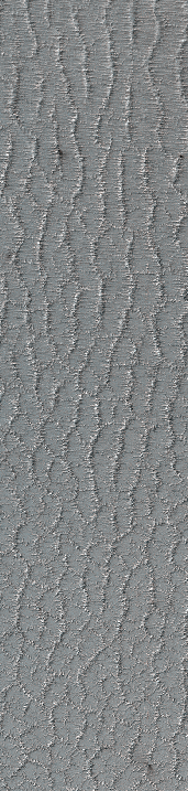
And now there's this to consider - http://www.uahirise.org/ESP_031138_1380
Heres a crop that I rotated by 90 for comparisons sake - screww your eyes up and then go compare with the big image at the beginning of the thread. The scale is compressed in this one but I think it's the same idea. 031138_1380 first then a bit of 011348_0950
 which is the first post on here
The way the long dunes with the 'bars' evolve into the polygonal ones is very similar to whats going on with the lace spiders..................
Posted
-
by
p.titchin
in response to wassock's comment.
Hi Wassock, great image. On the 'big picture, the ice in which these strange dunes appear looks almost like a terrestrial glacier and appears to have evidence of 'flow'. I also note on the site origin big picture, it seems to be in a crater~ but you are the crater guru, so reveered Masuto, I await the wisdom, and stand back to see what others think. I'm fascinated as always by what we see in these enigmatic Mars images,and await for the ideas! 😃 ~ Pete
Posted
-
by
wassock
moderator
Pete the picture on the left above comes from the bottom of a large crater, when you see the whole of it in Hi-Rise it's very obviously wind blown dunes. But the way the grade from ridges to close grouped dunes is close to the way the terrain changes inh the evolution/degradation image
Posted
-
by
wassock
moderator
Pete the left hand image f above is from the bottom of a large crater and when yo see the whole of it, is fairly obviously wind blown dunes. But the way the dunes 'evolve' from linear structures with crossing ribs in to the close grouped dunes is very similar to the way the terrain changes in the evolution/degradation strip. So maybe we're looking at an area that was once dunes and the spiders are following the 'fossilised' terrain?
Posted
-
by
wassock
moderator
OK been taking another look at this. What we see could be explained if we were looking at a traveres across a dried out lake. The polygonal cracking showing where the mud at the bottom laid thickest and the spidering of the cracks down to weathering of all sorts over the ages since it dried. Google dry lake bed and look at a few pics to see the similarity.
Posted
-
by
wessy3
There seems to be a dome shaped object in the picture? It occurs on the right side of the image, just as the smooth surface gets bumpy.
Posted
-
by
Kitharode
moderator
in response to wessy3's comment.
Hi wessy3. The object is nicknamed the 'space chimney' and it has been much discussed. What it really is, and how it formed, are questions that still need answering.
Check out page 3 of this discussion: http://talk.planetfour.org/#/boards/BPF0000002/discussions/DPF00001m0 for an amazing close-up picture. Cheers.
Posted