colour
-
 by
wassock
moderator
by
wassock
moderator
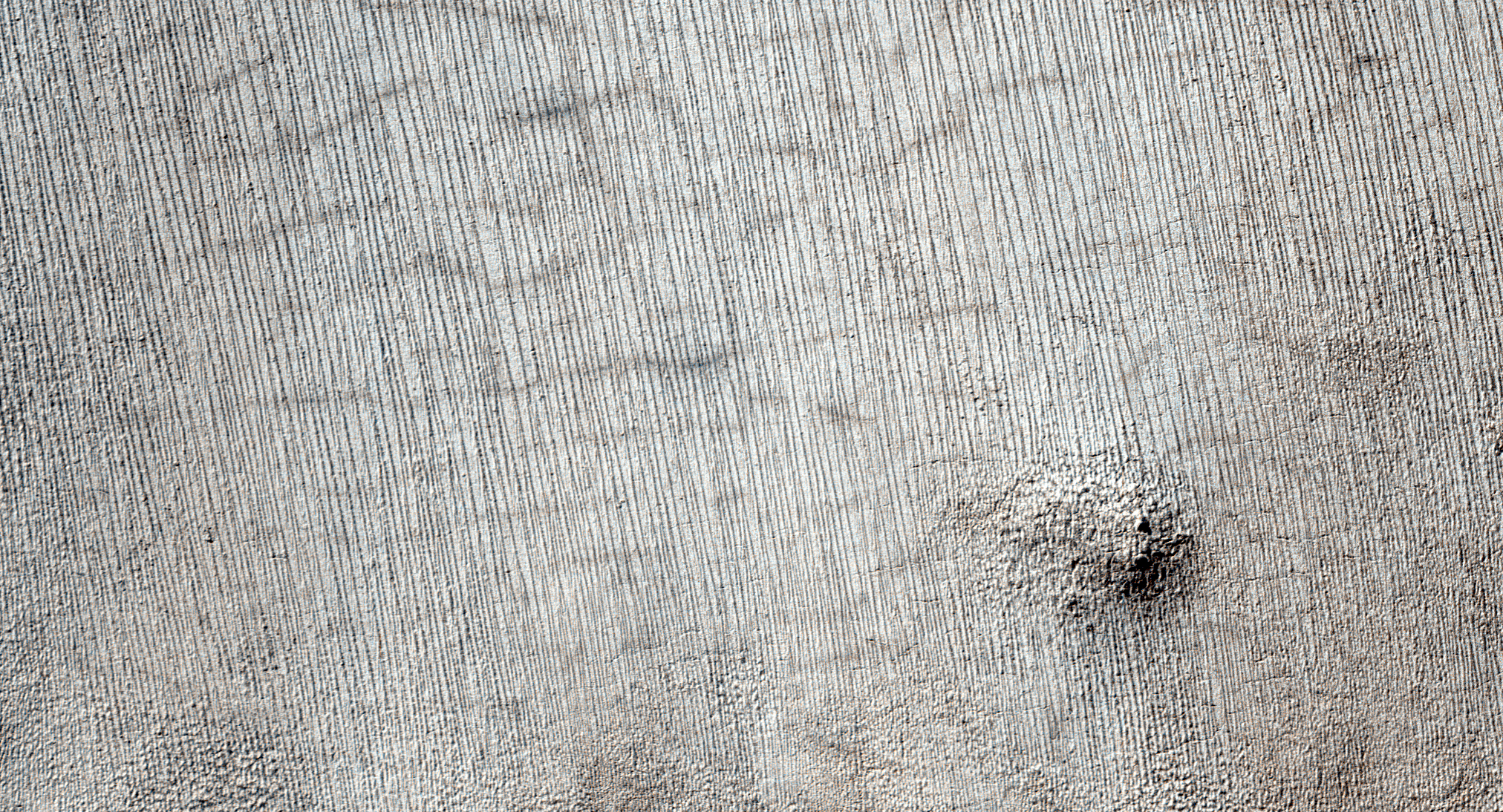
I'd kind of assumed that the variations in colour see in the various yardang images were down to varying camera/light effects. Take a look at the HiRise RGB.jpg image for this one and scroll down.
At the very bottom there's some sort of honeycomb effect going on
Posted
-
 by
p.titchin
in response to wassock's comment.
by
p.titchin
in response to wassock's comment.
'honey comb' effect is reminiscent of the polygonal ice plates we see- food for thought! The HiRISE strip shows an amazing change in colour! I notice that the sun was only 17 degrees above the horizon when the image was captured. Is this effect possibly due to the image covering an area running from full light into twilight?
Posted
-
 by
Kitharode
moderator
by
Kitharode
moderator
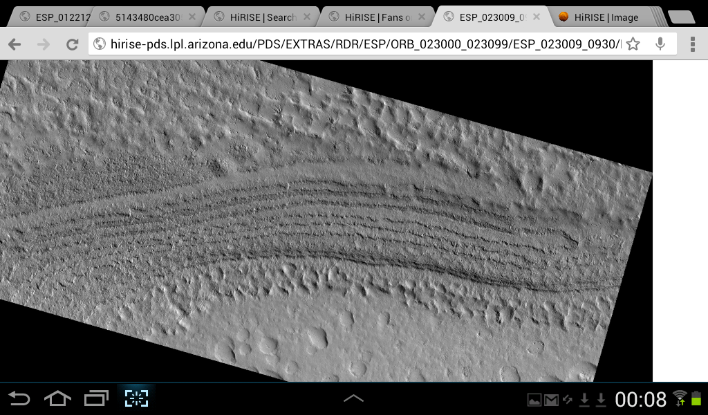
The image is from the 'Giza' region, on the polar layered deposits.
From the HiRise catalogue: "The South Polar Layered Deposits of Mars are a thick stack of layers of ice and dust, deposited over millions of years. The rate of deposition changes over time, and in some times and places the stack is eroded. ... Images like this one (link below) can show us where the layered deposits are being eroded, and how much ice and dust has been lost. This, in turn, helps us understand the history recorded in the layers".
http://hirise.lpl.arizona.edu/images/2013/details/cut/ESP_032020_0955.jpg
Posted
-
by
p.titchin
in response to Kitharode's comment.
The change over the image strip is so uniform and gradual I I can't see this as layering. I have seen images of the layers in other views,. They seem to show as exactly that,,,-layers! I like the image you give us, ta, I notice within it there are again faint polygonal shapes like the ones Wassock points out in his image. Definately food for thought!! Like Wassock, to me his image( Hirise) looks much more like a gradation in camera/light changes. The low light incidence for the centred image seems to fit this. Just thoughts, I wait for the moderator wrist slap!!! I remain fascinated by the images we get.
Posted
-
by
wassock
moderator
in response to p.titchin's comment.
good plan if that works and assuming that we're not looking at a negative image in some way I would have expected the end nearer the sun (the bottom) to be the brightest.............
my understanding of the layers is that we see them as erosive exposures - in the sides of steep valleys. for the yardang explanation of the parallel lines this whole region needs to be fairly flat or on a steady constant gentle slope methinksPosted
-
by
wassock
moderator
in response to Kitharode's comment.
nice image kith, And its got a boulder with a pointy shadow in it!
Posted
-
by
wassock
moderator
in response to Kitharode's comment.
wrt the layered deposits. There are no techtonics going on here so no uplift, folding or inclined beds so any sedimentation forms basically flat layers. the exposed layers are 10's or 100's of metres thick and to see them something must therefore have dug a big hole at some stage. What I'm not seeing is any explanation of where all the material that hasbeen removed is now.
Posted
-
 by
mschwamb
scientist, translator
by
mschwamb
scientist, translator
No hole is really needed - on the edges of where material was deposited wind erosion can reveal the other layers below or further in of the polar layered deposits if they have different strengths to erosional processes. This wind excavation has been going on a long time so the grains removed are taken with the wind and deposited over a wide area i'd imagine. To give an Earth analogy -There is wind erosion at the Grand Canyon walls but you don't see an area where all the removed material is .
Cheers,
~Meg
Posted
-
by
Kitharode
moderator
South Polar Layered Deposits (SPLD)
Kolb & Tanaka (2006): "Uneven depositional surfaces and/or modest settling and tilting of SPLD over irregular topography may explain the dipping beds".
Milkovich & Plaut (2008): "An individual layer within the SPLD is thus not horizontal, nor does it follow the surface topography precisely".
Pete has already indicated that the best place to view the layers is at the edges of the deposits where several layers can be seen at once. However, in certain places it can be seen that the topmost layer has been so badly eroded that the underlying layer shows through. It's not impossible that the polygon shapes in both wassock's and my images are either the remnants of a 'cracked' top layer, or the first signs of a polygonal under layer.
Pete: In wassock's HiRise image I'm more inclined towards ice, less ice, little/no ice, rather than changes in lighting.
Posted
-
by
p.titchin
in response to Kitharode's comment.
Hi Kith, I've spent 6 hours today going over these images and doing the light incidence sums and looking at any similar images. I was coming back on line to say 'mea culpa',, and suggest this was simply the change in colour as the ice thinned! I find you have already succintly stated the case . I suspect this is the answer. I am very interested in the honeycombing, as i feel these offer information in the spider channel/network theories, which fascinate me enormously.. As I keep saying- Happy Days!!
Posted
-
by
p.titchin
in response to mschwamb's comment.
Lovely analogy Meg,I'm going to keep my powder dry as to where I think the wind eroded material in the GC is now and how we apply it to Marsa Might be a fun thread!!
Pete.
Posted
-
by
Kitharode
moderator
in response to p.titchin's comment.
Pete: I'm with you on polygons and spider channels being heavily connected. The precise 'how and why' of it all escapes me, but the gut feeling and the images are overwhelmingly in favour. 😃
Anybody: Also from Milkovitch & Plaut
"While certain layers are correlatable over hundreds of km, implying widespread deposition of polar material, the absence of several identified layer sequences in some regions ... indicates that deposition and sublimation or erosion of these deposits has not been uniform around the SPLD. This is further supported by the fact that individual layers display variations in thickness greater than a factor of 4 over hundreds of kilometers".
Posted
-
by
mschwamb
scientist, translator
in response to Kitharode's comment.
Well I think spider channels may exploit already formed polygons as Anya also suggested. Polygonsl cracks form due to a freezing/thawing cycle. They are actually found on Earth as well in the artic and Antarctic regions. This article talks a bit about their formation.
Cheers,
~Meg
Posted
-
by
wassock
moderator
in response to mschwamb's comment.
Meg, I'm operating under the illusion that where we see the layers we are looking at a series of cliffs and flats of various slopes an that from one side of a series of layers to the other as viewed from above represents a change in altitude. the layers seem to come in pairs as sides of valleys or a ridge. I'm further assuming the the layers are them selves more or less horizontal and thus the layer at the bottom was once beneath all the other layers. Consequently theres alot of material been removed to expose the visible layers. Wind erosion in the grand canyon will eventually deposit dust into the colarado and the material so removed will end up at the bottom of the Pacific where the satellites cant see it. Or have I got the wrong idea about the topogrsphy of these exposures?
Posted
-
by
wassock
moderator
This is a pic of said deposits I read this image as showing 2 flatish areas, top left/bottom right separated by the layers and that there is a significant difference in elevation between the 2 flat areas?
Posted
-
by
Kitharode
moderator
in response to wassock's comment.
Wassock. That's just one set of edges from one location. There are others. See if this link works http://www.google.co.uk/url?sa=t&rct=j&q=&esrc=s&source=web&cd=17&cad=rja&ved=0CFMQFjAGOAo&url=http%3A%2F%2Fwww.researchgate.net%2Fpublication%2F236542805_Martian_South_Polar_Layered_Deposit_stratigraphy_and_implications_for_accumulation_history%2Ffile%2Fe0b49517ff59c569c0.pdf&ei=fUHpUd3rKY-O7QaZtoHQCg&usg=AFQjCNE4ywh8UeDd4wH8JoWS61xPnm-i_g&sig2=As3cv0tlkq_acPKHKW3OVg&bvm=bv.49478099,d.ZGU
It's a PDF so I don't know if it'll come across ok.
Posted
-
by
wassock
moderator
in response to Kitharode's comment.
Well that one's not going to win any prizes from the plain English society. But we have kilometer thick piles of layered material which has been eroded into chasms. Thats erosion on a grand canyon scale meaning lots of material has been removed and put somewhere else, So the question remains how and where?
Posted
-
by
mschwamb
scientist, translator
in response to wassock's comment.
I think timescale is the key- wind erosion acts on very long long timescales. I think this article might be what you're looking for.
Cheers,
~Meg
Posted
-
by
wassock
moderator
OK that kind of works for me and a weighty paper to read to boot! will pause for breath
Posted
-
by
p.titchin
in response to mschwamb's comment.
Thanks for the 'article' link, so much to ponder over. It seems applicable to so much we've been shown in the images. Brain now working overtime, and trying not to get indigestion!!
Posted
-
by
mschwamb
scientist, translator
in response to p.titchin's comment.
I was typing on an ipad in a conference in Germany. I did mean to write paper instead of article.
Cheers,
~Meg
Posted
-
by
p.titchin
in response to mschwamb's comment.
Meg, it's sure enough a paper and a half +++ for me!! Its got enough meat for me to try to chew for months! I can only say again , many thanks for the link.
Pete.
Posted